
![]()
|
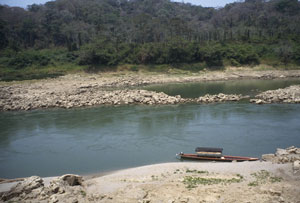
(The thrill of moving along an ancient jungle waterway was overwhelming. We especially enjoyed the moments when the motor was quiet. We traveled in the rig pictured in the image link that directed you to this narrative; note the vessel's original primitive design. Also take a look at that unbroken jungle wilderness across the river in Guatemala; behind us is the camp and ruins and behind that is more unbroken jungle wilderness. The shorelines are replete with crocodiles and huge iguanas; the trees harbor very vocal howler monkeys and exotic tropical birds. This is heaven!)
|
|||
|
"JOURNEY TO YAXCHILAN"
|
|||
|
"There aren't any hotels out there, or restaurants or showers or the like," firmly stated the "tour operator" as he graciously accepted the payment for two rugged days in the backcountry of Mexico.
We had come here specifically to observe, absorb and photograph Mayan ruins. After a successful time at Palenque we had hoped to arrange a trip to the wilderness ruins of Yaxchilan and Bonampak. Our wish would apparently come true.
Until recently the only access to these places was by aircraft, which had been the transportation of choice for research Mayaists and archaeologists who had originally explored the sites. Yaxchilan is known for its artistic architecture, elegantly carved lintels (doorway headboards) and remote setting. The ruin lies along the Rio Usumacinta, a waterway which divides the remote lowland jungle regions of Mexico and Guatemala. When one refers to the maps of the area, both sides of the river show minimal settlements, few roads, no bridges -- just the word "jungles" appears on the documents. A small and rough access road allows entry to the river at a point perhaps twenty kilometers upstream from the site of Yaxchilan. Most access is now from the river; the old airstrip, we will discover, is useful mostly for camping and grazing.
After some initial confusion we are picked up and introduced to the Spanish-speaking-only Francisco. He will be our guide for the two day outing. We will go to the market for supplies and "refrescos," then proceed by the highway -- and then by gradually rougher and more remote roadways -- edging ever so slowly to the ancient river. Our companions on the journey are two married couples: Christina and Giones from Italy (multilingual, with Spanish as a second and English as a third language) and Frank and Ron, a male married couple from Holland. They too speak some English, but no Spanish. The group is a good one, possessing much language and social diversity.
After four cordial, almost friendly, military checkpoints (this is, after all, guerrilla warfare central -- the very locale of Sub-commandant Marcos, the blue-eyed, college-bred leader of the anti-government, anti-NAFTA rumblings in Chiapas), we arrive at the river.
It's a wide affair with substantial current for a waterway of this size. I estimate it to have the volume of an average flow of the Colorado River through the Grand Canyon. When we reach our campsite, I will have an eloquent conversation with our boatman (not Francisco, but another individual) and his assistant. (We have found that when participating on a guided trip in Central America, the "tour" essentially picks up guides as it proceeds, and they all continue along until the conclusion. The above-mentioned strategy allows for many points of view and much socializing, a most attractive way of doing this sort of thing. I contrast their method with a much more formal set of guiding "constraints" associated with trips I've guided in the States.) During our discussion at camp (guides in Spanish, myself in English) we determine that the river is at it's low point. Being a free flowing river -- very rare worldwide in 1995 -- the waterway does swell dramatically during the rainy season (May through November); at this time it rises in some spots (including our campsite) an incredible forty feet from the present level.
"Put-in;" we are to proceed downriver in a long boat replete with thatched roof. The only feature which differentiates this craft with one 1000 years previous is the presence of a large outboard motor. We climb in, get comfortable and immediately advance to the right bank of the river for a refreshment in Guatemala. No customs, immigration or officials here; it is a village of perhaps fifty people, and the only settlement for 100 miles in all directions. Yet, because of the river access, the proprietors of the small cantina offer a wide assortment of coolish beverages and a full line of cigarettes. Chickens, mangy dogs and refuse litter the immediate area of the store and an ancient village looms beyond at jungle's edge.
Back on the boat; we are back in time. We pass great Turkey Vultures (perched, with spread wings in full splendor), White Egrets (walking the shore in search of fish), huge green and brown iguanas (their three foot bodies posed lazily on shoreline rock outcroppings): all rather disinterested while this surprisingly greenish-clear river flows by as it has for millennia. The dense jungles of Guatemala and Mexico begin to close in. We float downriver through one of the last great lowland rain forest wilderness areas of Mesoamerica. This is a place that must accept the burden of time and history, the recognition that it's people were once the most advanced society on the planet. The human inhabitants now live as almost forgotten reminders of their splendid past. The jungle has grown back from past agricultural abuses, and this living arena seems almost to revel in personal rejuvenation. It is a rare place. The jungles of Mesoamerica -- and others throughout the world -- are being cut again for agriculture. If Mayan texts would have been saved, they would have undoubtedly spoken of over-urbanization and resultant land use crises. Perhaps modern peoples could have learned from the Maya's initial mistakes.
I am broken from this rambling philosophy; we are passing the ruin and pulling into camp. We climb a steep hill (caused by erosion at high water) and view the site for the first time. To our left and through the forest via trail the ancient structures loom. Straight ahead, and along the obvious airstrip (now very green with recent rains and no traffic) we note a small village with neatly arranged thatched huts.
There is a covered "picnic" area directly to our left; this is where we stow our gear. The cook (for the village and all visitors) is an elder woman of Maya descent. After obligatory unloading and such, we meet yet another Spanish-speaking guide -- a "ranger" I would say -- and are treated to a three-hour personal tour through the ruins, which include magnificent structures, catacombs, mazes, vampire bats (nervously-spoken "vampira" -- even I can understand that,) spiders and magnificent sculptures in stone. We walk through the rain forest and back to camp as dusk begins to descend on the jungle.
|
|||
|
All design and content copyright Greiner/Price, all rights reserved. |
|

